




By Global Energy & Environment News Desk
Updated: October 7, 2026
Main Facts: A Rare and Dangerous Late-Season Threat
Hurricane Isaias surged dangerously toward the U.S. Gulf Coast as the first hurricane of a remarkably subdued Atlantic season. The rapidly intensifying storm prompted mandatory evacuations, extensive school closures, and local government shutdowns across vulnerable municipalities in Florida, Mississippi, and Alabama.
Carrying maximum sustained winds of approximately 85 mph (140 kph), Isaias represents a meteorological anomaly. Developing more than four months into the Atlantic hurricane season, the storm fell just one day short of tying a 121-year-old record for the region’s latest-forming hurricane. That historic benchmark was set on October 8, 1905.
Forecasters warned that the system would bring life-threatening hazards to the northern Gulf Coast, including destructive winds, an overwhelming storm surge, torrential downpours, and the potential for isolated tornadoes. In response to the looming disaster, regional power companies and electrical cooperatives mobilized massive restoration forces, staging heavy equipment, clearing vegetation, and activating mutual aid networks long before the first bands of the storm made landfall.
Chronology: Path, Progression, and Atmospheric Context
The Formation and Trajectory
As of early Thursday afternoon, Isaias was located approximately 355 miles (570 kilometers) south of the mouth of the Mississippi River, tracking east-northeast at a forward speed of 10 mph (17 kph). Meteorologists tracking the system noted that warm Gulf waters were providing the necessary fuel for rapid intensification.
The hurricane was projected to make landfall late Friday or early Saturday along the northern Gulf Coast, directly impacting the Florida Panhandle, southern Alabama, and southern Mississippi. While the system is expected to weaken quickly once overland, forecasters warned that its remnants will dump heavy, continuous rain and trigger localized flooding well into the weekend, stretching as far north as Tennessee and North Carolina.
A Quiet Atlantic vs. An Active Pacific
The unusual timing of Isaias is directly tied to broader global climatic patterns. The 2026 Atlantic hurricane season has been remarkably quiet due to a persistent and strong El Niño event, which disrupts atmospheric conditions and suppresses tropical cyclone formation over the Atlantic basin.
Conversely, storm activity has been above average in the Pacific Ocean. While Isaias gathered strength in the Gulf, Tropical Storm Simon formed off the coast of Mexico, and Tropical Storm Rachel was tracked on a trajectory expected to approach northern Baja California and Southern California over the weekend. This stark contrast highlights the complex, shifting dynamics of global weather systems under the influence of large-scale ocean-atmosphere interactions.
Supporting Data: Meteorological Projections and Impacts
The quantitative threat posed by Hurricane Isaias is underscored by high-impact projections from the National Hurricane Center and regional meteorological services:
- Wind Speeds: Maximum sustained winds reached 85 mph (140 kph) prior to landfall, capable of snapping utility poles, tearing down distribution lines, and causing structural damage to poorly secured infrastructure.
- Storm Surge and Tides: Combined water levels from the storm surge and high tide are forecast to reach 5 to 7 feet (1.5 to 2 meters) in isolated coastal sectors of Alabama and Mississippi.
- Rainfall Totals: Coastal areas face up to 15 inches (38 centimeters) of cumulative rainfall, creating severe flash-flood risks.
- Tornado Threat: Environmental conditions overnight Friday into Saturday will favor the formation of spin-up tornadoes stretching from the eastern boundaries of Alabama across the Florida Panhandle and into southwestern Georgia.
- Historical Precedent: The storm’s late October formation mirrors the historic 1905 season, placing it in an exclusive historical category for late-season tropical activity in the Atlantic.
Official Responses: Electric Utilities Mobilize Massive Pre-Landfall Operations
With widespread outages anticipated across multiple state jurisdictions, energy providers and municipal electric networks activated emergency response protocols days ahead of potential impact zones.
Florida Power & Light Company (FPL)
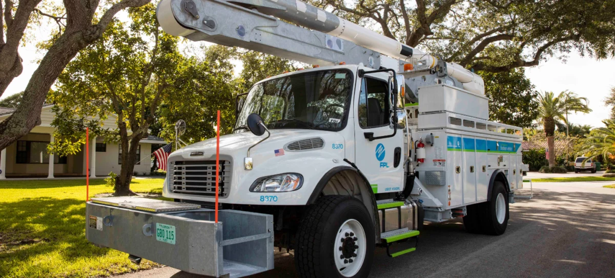
Florida Power & Light Company activated its comprehensive emergency response plan, pre-positioning a dedicated restoration workforce of approximately 12,000 personnel. FPL finalized 16 processing and staging sites strategically designed to expedite power restoration "closest to areas likely to feel the greatest impact." The utility augmented its internal workforce by securing specialized restoration crews from out-of-state utilities and private electrical contracting firms.
"At FPL, we are moving crews and resources in advance of Tropical Storm Isaias so we can respond immediately and quickly restore power for our customers," said FPL President and CEO Scott Bores. "We’re prepared and ready to respond. We urge our customers to prepare, too. Please take this time to review your emergency plans, closely monitor the storm and follow guidance from local and state officials."
Georgia Power
Georgia Power deployed emergency response teams and heavy-duty storm equipment into its western and central service territories, which are expected to bear the brunt of the weather system. Crews have been actively trimming trees near critical power lines to mitigate potential tree-fall outages. Additionally, the company rolled out automated SMS-based power outage alerts to keep its customer base informed in real time.
Duke Energy Florida
Duke Energy Florida mobilized emergency response teams across its service zones. However, utility officials issued stern warnings that adverse weather conditions—including high winds and localized flooding—will likely hamper initial travel and field operations, pointing toward "lengthy and difficult" repair timelines.

"As Hurricane Isaias approaches, Duke Energy meteorologists are closely tracking the storm. Our crews are prepared to restore power as soon as conditions allow," stated Todd Fountain, Duke Energy Florida storm director. "The safety of our customers, communities and employees remains our top priority."
CenterPoint Energy
Operating further west, CenterPoint Energy’s meteorology, emergency planning, and gas and electric operations teams monitored the system closely. While initial tracking indicated no direct impacts to the Texas Gulf Coast or the Greater Houston area, the utility maintained a state of high readiness.
"CenterPoint’s meteorology team continues to monitor newly named Tropical Storm Isaias as it continues to strengthen and move northeastward in the Gulf. Based on the latest data and forecast, no direct impacts are expected for the Greater Houston area," said Marco Monreal, CenterPoint’s Lead Meteorologist. "While we are not expecting impacts, our teams are taking action and reviewing readiness plans, and we encourage all customers across southeast Texas to stay weather aware."
Entergy Mississippi
Entergy Mississippi directed its crews to monitor the system closely, focusing resources on the eastern portion of its service territory. Utility officials warned that heavy winds and saturated soils could cause significant infrastructure damage, particularly in rural and suburban regions where vegetation remains compromised following insect infestations tied to a severe regional drought in 2023.
Baldwin EMC
Serving the coastal corridor between Mobile, Alabama, and Pensacola, Florida, electric cooperative Baldwin EMC placed all field personnel on emergency storm alert status, monitoring meteorological shifts around the clock.
"We want to assure our members we are prepared should Tropical Storm Isaias reach our service area," said Mark Ingram, VP of Corporate Services and Public Relations. "We have a fine-tuned disaster plan in place, and we’ll be ready to respond within a matter of hours after the storm hits."
Baldwin EMC secured auxiliary supplies—including utility poles, transformers, and industrial-grade electrical wire—while positioning extra standby crews to manage anticipated widespread grid failures.
Florida Municipal Electric Association (FMEA)
Representing 33 public power communities and municipal utilities across the state that serve more than 4 million residential and commercial consumers, the Florida Municipal Electric Association activated its robust mutual aid network.
"It is anticipated that Hurricane Isaias will bring heavy rainfall, damaging winds, possible tornadoes, and storm surge and flooding, which could lead to widespread power outages in affected coastal and inland communities," explained Amy Zubaly, Executive Director for FMEA. "At this time, Florida’s public power communities remain outside of the current forecast cone. However, all Florida municipal electric utilities are prepared to respond and assist with recovery."
Implications: Economic, Operational, and Grid Resilience Lessons
The arrival of Hurricane Isaias late in the calendar year carries profound implications for municipal planners, emergency managers, and the energy sector at large.
First, the event challenges traditional assumptions regarding the temporal boundaries of the Atlantic hurricane season. While statistical models often point to a late-summer peak in August and September, anomalous warm water currents and shifting climatic variables demonstrate that destructive tropical systems can materialize well into the autumn months, requiring year-round vigilance from critical infrastructure operators.
Second, the aggressive pre-staging of multi-state utility workforces underscores the evolution of modern grid management. By leveraging mutual aid agreements—such as those coordinated by the FMEA and major investor-owned utilities—energy providers are increasingly capable of compressing restoration timelines following catastrophic weather events. However, utilities face persistent operational hurdles, such as managing compromised vegetation from prior droughts and navigating flooded roadways that delay damage assessment.
Ultimately, Isaias serves as a stark reminder of the vulnerability of coastal energy infrastructure. As regional authorities evaluate damages in the wake of the storm, the emphasis among utility operators will inevitably return to long-term grid hardening, undergrounding distribution lines, and refining predictive artificial intelligence models to anticipate storm tracks and power failures with pinpoint accuracy.