




By Industry News Desk
Published: October 22, 2026
Main Facts
The solar industry has reached a critical inflection point regarding operational efficiency, software integration, and the speed at which residential and commercial solar installations move from conception to interconnection. On October 22, 2026, renewable energy software leader Aurora Solar announced a major capability expansion bridging the gap between aerial data collection and end-to-end solar project design.
For years, solar contractors have recognized the immense value of drone technology. A well-executed drone flight captures high-resolution imagery detailing complex roof structures, including precise roof pitches, ventilation obstacles, and adjacent shading elements from surrounding foliage. However, a persistent bottleneck has plagued the industry: the fragmented workflow required to turn raw aerial data into permitting-ready designs.
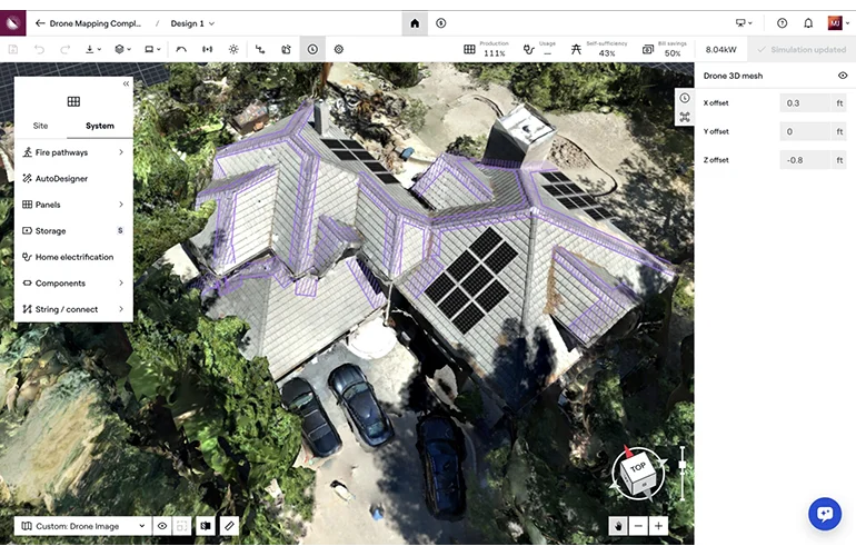
Until recently, professionals had to juggle multiple disconnected software ecosystems. They would use one platform for drone data capture and mapping, export those files, and then manually import them into a separate design tool—often sacrificing the remote design accuracy needed to avoid costly change orders. Aurora Solar’s latest solution addresses this friction directly, creating a unified pipeline that connects high-precision drone mapping with remote design, proposal generation, and permit-ready documentation within a single platform.
Chronology: The Evolution of Solar Design and Aerial Mapping
To understand the significance of this technological leap, it is helpful to examine how solar design methodologies have evolved over the past two decades.
Phase One: The Era of Manual Measurement (Pre-2010s)
In the early days of the modern residential solar boom, site audits were almost exclusively manual. Installers climbed onto roofs with tape measures, compasses, and solar pathfinders. They recorded pitch, azimuth, and shading variables by hand, translating those notes into rudimentary 2D sketches. This process was time-consuming, labor-intensive, and fraught with human error, frequently resulting in inaccurate shading estimates and system underperformance.
Phase Two: Satellite Imagery and Remote Estimates (2010s–Early 2020s)
As high-definition aerial satellite imagery became widely available through mapping APIs, software platforms like Aurora Solar revolutionized the industry by introducing remote design. Contractors could generate accurate proposals without ever visiting the site, drastically reducing soft costs and accelerating sales cycles. However, satellite imagery has inherent limitations: it struggles with heavy tree cover, complex architectural features, low-resolution angles, and newly constructed homes where satellite data lags behind reality.
Phase Three: The Rise of Commercial Drones (Mid-2020s)
Recognizing the limitations of satellite data, solar contractors increasingly turned to Unmanned Aerial Vehicles (UAVs). Drones empowered field teams to capture centimeter-grade aerial maps of challenging roofs in a matter of minutes. Yet, this created a new operational challenge. The software used to stitch drone images together (photogrammetry software) operated in a silo. Technicians had to export Orthomosaics or 3D point clouds and manually calibrate them into design software. The extra steps introduced data degradation, scaling errors, and compatibility issues.
Phase Four: The Unified Workflow Integration (October 2026)
With the latest updates from Aurora Solar, the industry has transitioned into an era of native integration. Drone mapping data is no longer treated as an external file type; instead, it feeds directly into an ecosystem built for high-accuracy remote design, financial modeling, and permit plan-sets, removing the friction points that previously slowed down project lifecycles.
Supporting Data: The Economics of Efficiency in Solar Construction
Soft costs—customer acquisition, engineering, permitting, and design—continue to make up a significant portion of total solar installation expenses. According to recent industry analyses from renewable energy research firms, reducing administrative and design friction can yield substantial financial returns for engineering, procurement, and construction (EPC) companies.
- Design Reductions: Traditional workflows require designers to spend an average of 45 to 90 minutes cleaning up, scaling, and calibrating external aerial or drone files before actual module placement can begin. Integrated platforms reduce this preparation time by up to 70%.
- Error Mitigation: Change orders resulting from inaccurate roof measurements account for roughly 8% to 12% of residential installation cost overruns. Centimeter-accurate drone mapping integrated directly into design software slashes these discrepancies, minimizing post-sale redesigns.
- Permit Approval Velocity: Jurisdictions reviewing solar permit applications frequently reject plans that feature ambiguous roof dimensions or unverified setbacks. Plans generated from verified drone datasets feature higher first-pass approval rates, reducing interconnection and AHJ (Authority Having Jurisdiction) delays by days or even weeks.
Official Responses and Industry Perspectives
The announcement has generated widespread discussion among solar contractors, software developers, and industry analysts regarding the future of remote operations.
"Flying drones isn’t just fun, if you’re in solar you know it has real value, too. A good, well-planned flight captures the roof in detail: every vent, every pitch change, every tree throwing shade," noted representatives from Aurora Solar in their official product release.
"The trouble, of course, is what comes after the flight. Until now, no single platform could give you drone mapping with Aurora-level remote design accuracy, and everything else it takes to get from first design to signed permit. So you’ve really had a couple options, and neither one is ideal."
Early-adopter contractors have echoed these sentiments, pointing out that software fragmentation has long been an unnecessary tax on business growth.
"When you are scaling a regional solar business, every minute your design team spends transferring files between software silos is money left on the table," said Marcus Vance, Chief Operations Officer for a multi-state solar EPC. "Having drone data talk directly to your design platform means our salespeople can close a deal in the morning, our field techs can fly the roof by lunchtime, and our engineers can have a permit-ready package finalized by the end of the day without ever second-guessing the dimensional integrity of the roof."
Another prominent voice in solar systems architecture noted that the convergence of UAV hardware and advanced cloud-based design tools represents the pinnacle of modern digital transformation for contractors. "The companies winning market share today are not necessarily the ones with the cheapest panels; they are the ones with the lowest customer acquisition and engineering overhead. Unified software is the engine driving that cost reduction."
Implications for the Future of the Solar Industry
The integration of native drone mapping into comprehensive solar design platforms carries profound implications for the trajectory of the renewable energy sector over the remainder of the decade.
1. Democratization of Complex Commercial Projects
While residential solar has leaned heavily on satellite data, commercial and industrial (C&I) projects have always required intensive on-site validation due to expansive roof sizes, complex HVAC layouts, and multiple roof planes. By seamlessly fusing high-volume drone data with cloud-based design engines, smaller regional installers can now pitch and design complex commercial projects with the same speed and accuracy previously reserved for enterprise-level engineering firms.
2. Accelerated Labor Productivity and Workforce Development
As the clean energy economy expands, the solar industry faces persistent labor shortages, particularly among certified designers and electrical engineers. By automating the data-import and scaling processes, software platforms allow existing design personnel to handle higher project volumes. Furthermore, intuitive user interfaces lower the learning curve for new hires, enabling junior technicians to generate accurate layouts safely and quickly.
3. Heightened Consumer Confidence and Shading Transparency
For homeowners, one of the most frustrating aspects of going solar is discovering post-installation that shading is worse than projected, leading to lower-than-expected energy offsets. Detailed drone mapping combined with advanced solar irradiance modeling provides homeowners with hyper-accurate production estimates. This transparency builds trust between consumers and contractors, reducing cancellation rates and boosting referral business.
Conclusion
As software solutions like those offered by Aurora Solar continue to mature, the barriers separating field data collection from office-based design are rapidly dissolving. For solar contractors navigating a competitive market, adopting streamlined, all-in-one workflows is no longer just a luxury—it is an operational necessity. By bridging the gap between the drone in the sky and the permit on the desk, the industry is poised for a new era of unprecedented speed, precision, and profitability.